• This website includes dozens of videos, hundreds of essays, and thousands of drawings created over the past twenty years. Search to learn more about the history of buildings, places, prisons, Newark, New York City, and my PhD research on spatial inequality.

  • Or scroll down for the latest publications.

Built on a Billion-Dollar Bed of Corporate Tax Breaks

What kinds of tax breaks are we giving to redevelop Downtown Newark?
Who is getting them?

An investigative report on public funds for private profit.

.

“Free enterprise is a term that refers, in practice, to a system of public subsidy and private profit, with massive government intervention in the economy to maintain a welfare state for the rich.”
– Noam Chomsky

.

Contents

[1] Who owns the land around Mulberry Commons?

[2] If past predicts future, what kind of past tax breaks have we given?

[3] The problem is not tax breaks. The problem is: Who gets them?

[4] How can we ensure equitable economic development in Newark?
Five policy recommendations.

.

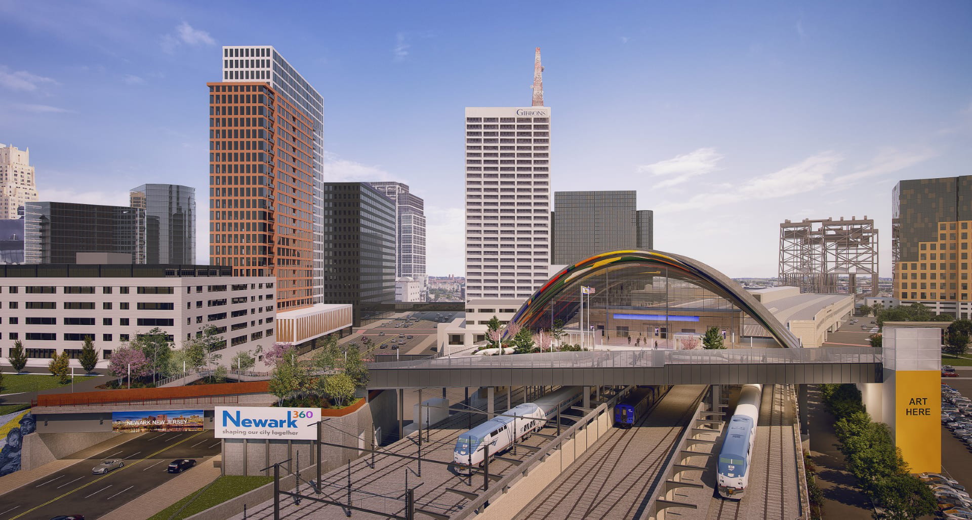
Artist’s rendering of Newark Penn Station expansion

.

Introduction: A Case Study in Edison Parking

The City of Newark borrowed $110 million to pay for a pedestrian bridge over Route 21. This new link between Mulberry Commons and Penn Station will allow travelers, event goers, and sports fans to walk directly from the trains to the games at the arena. Newark City Hall and the media are describing this as Newark’s equivalent and response to New York City’s High Line. This project follows on the already $10 million spent on building Mulberry Commons.
As part of misguided car-centered 20th-century urban planning, thousands of highways were built in our nation through low-income communities of color, to divide the less privileged in hundreds of places like Newark. Through the tools of public investment in public space, now is a moment to make wrong historical injustices like Route 21, Route 22, Interstate 78, and Interstate 280. Now is a historic opportunity for the urban form as tool of reparations.
However, what parts of the public – divided across lines of race, income, and home address – will benefit the most from this project? Will the benefits of this investment disproportionately go to a few people or institutions, such as Prudential Center patrons and Edison Parking tenants?

Read More

.

The Paterson Silk Strike in Historical Perspective

1913 to 2023


A century later, the mills of Paterson sitting abandoned, their machines silent

Exactly 110 years ago today – on July 28, 1913 – Paterson silk mill workers voted to end their strike. Their strike had failed. But what has changed (or not) since then frames their historical struggle in the context of ongoing labor battles. The motivations of the strikers are as relevant in 2023 as they were in 1913: the fight for a living wage, for an eight-hour day, and – ultimately – for the right to work that feels meaningful.
The silk looms of Paterson required a high level of skill to operate: to draw the thin threads into delicate patterns, to weave the silk without breaking it, to never pull the threads too tightly that embroidered patterns curled up into themselves. Machines kept the rooms humid all year round – hot in summer, cold in winter – so that the silk threads remained damp, malleable, and less likely to tear from dryness. Workers suffered in the moisture; cases of asthma and lung diseases were common. Management was threatening to replace their skilled labor with machines. Whatever creativity and skill was still required to operate the looms was gradually being lost. Thousands in Paterson went on strike for five months from February to July 1913. They ultimately failed when management refused to concede to their demands and when workers in other mills refused to join in solidarity.
The machines in Paterson were powered first by water and wood, then coal, and finally electricity. The inventors of mill machines were scattered across the New York region. Factory machines needed to be close to the men who invented them and repaired them when, inevitably, these new inventions broke down. The investors in silk were on Wall Street and Lower Manhattan. The markets selling silk were department stores on Manhattan’s Ladies Mile, better known as Sixth Avenue. (Sixth Avenue was still largely residential.) A popular saying ran: 8th Street down the men are making it; 8th Street up the women are spending it.
The distance between markets and manufacturers was once measured in miles, the distance by train from Paterson to New York City or the distance by foot from the Triangle Shirtwaist Factory to Ladies Mile. This distance is now measured in thousands of miles. In the 19th century, Jacob Riis shocked the city’s elite with photos of Lower East Side tenements and factories located less than a mile from their Fifth Avenue homes. On June 7, 1913, the Paterson strikers brought the strike to the city. They boarded trains to Madison Square Garden and re-enacted their strike on stage for an audience in the thousands. Some strikers played on stage as police, others as management, and others as themselves. It was one of the the first times in American history that labor was transformed into a public pageant, into a public spectacle that hoped to make visible their struggle to New York City consumers. Pageants were traditionally military and state affairs that celebrated events like battle victories, elections, and fancy dress balls in theaters. To put on as large a public spectacle to celebrate striking and strikers was something new.
Fearful for their property and of socialists on their doorstep, Upper East Side residents organized their own unit of the National Guard based in a custom-built Park Avenue Avenue castle. Nicknamed the Silk Stocking Regiment for the wealth of its members, they paraded annually down Fifth Avenue in a display of wealth and force.

Read More

.

A park without trees creates a city without history.

Harriet Tubman Square has the largest and most impressive collection of old-growth trees in Downtown Newark. The oldest trees are over 100 feet high, four-feet diameter at the trunk, and up to 150 years old. The City of Newark’s current proposal is to cut every single tree in our park. The only historical precedent for this is the 1960s project that killed every tree in Military Park to build the parking garage now buried beneath. Based on details and architectural plans revealed through an Open Public Records Act request, this animation shows what is planned for our park:

.

Read the plans for the park.

Read our analysis of these plans.

.

.

We cheer for the historic Harriet Tubman Park for a new, prosperous, and most of all just Newark.
However, nobody should even imagine cutting down these 66 century-old trees, oaks, elms, sycamores, all of which represent our history and particularly African-American experience. In America, trees symbolize both freedom and brutal oppression, should any sensible person forget. Unlike any historic treasures – architectural remnants, shriveled old maps, aged documents, or battled artifacts – these trees are among our most valuable historic icons, standing tall for our children.
Tubman embodied the notion of reclaiming the symbolism of trees and woods as tools of freedom in the black tradition. In the antebellum America, abolitionists always voiced lyrics about glorious trees that bore the fruit of freedom. Dr. Martin Luther King famously said, “Even if I knew tomorrow the world would go to pieces, I would still plan my apple tree.” Tubman was famous for knowing the terrain of trees, woods, and swamps along her journey to freedom. In Tubman’s biography by Sarah Bradford, the black Moses said, “When I found I had crossed that line, I looked at my hands to see if I was the same person. There was such a glory over everything; the sun came like gold though the trees, and over the fields, and I felt like I was in Heaven.”
On the other hand, Billie Holiday sang about fruits produced by these trees: “Southern trees bear strange fruit/Blood on the leaves and blood at the root/Black bodies swing in the southern breeze/Strange fruit hanging from the poplar trees/ …Here is a strange and bitter crop.” The blood of black men, women, and children who refused to remain silent, and who deserve justice, life, liberty, and love, over the hate that surround them.
Last year, Rutgers Newark restored the history and voices of Frederick Douglass in the Historic James Street Commons. Let us not forget, Douglas also said, “If Americans wished to partake of the tree of knowledge, they would find its fruit bitter as well as sweet.” It is unimaginable that Tubman will allow these venerable trees of knowledge to be annihilated.

We cannot design our way out of this crisis.

.

Design is supposed to solve the problems of pandemic and climate crisis. This is flawed thinking. The apostles of architecture, technology, and design confront crisis with what they call “design thinking.” They claim they can design our world out of crisis through new technologies: sustainable product packaging, vegetable-based meat substitutes, paper bags instead of plastic, wind and solar instead of coal and oil. Meanwhile, the global super rich build space ships that will allow them to one day escape the mess they made of our planet. “Design thinking” becomes a way of escaping this world entirely.
The techno-optimism of “design thinking” fails to recognize that “design thinking” is itself a poison. The problem is not with design per se. Rather, the problem is with the corporate power structures in which “design thinking” operates. They promise electric cars will replace fossil-fueled cars that pollute. They promise New-Orleans-style levees and elevated houses built on stilts will reduce property damage in flood zones. They promise improved artificial intelligence will stop the virus of online hate speech. They promise we are just one more consumer purchase away from happiness. But this techno-optimism does not address the deeper questions: Why are we not designing a society in which people do not need cars? Why are we building in flood zones in the first place? Why must the profit model of social media networks rely on users spending as must time as possible on their platforms, even when boosting engagement results in exposing users to hate speech? The limited palette of “design thinking” overlooks systemic solutions that require fundamental, but overdue, lifestyle changes.

Read More

.

Warren Street School Demolition

As featured in:
1. Darren Tobia for Jersey Digs

2. The Vector, NJIT’s student newspaper
3. Read my analysis of campus architecture for some context on this demolition.

.

.

“Those historians want to keep these old bricks. I can’t see why you’d want that s**t. F**k it. We might just slip in some new bricks. You can’t tell the difference anyway.”

– Conversation overheard between demolition workers at the Warren Street School

.

.

.

“The university has never demolished any historic building of any value. Name one.”

– President of the university during a community meeting in October 2020

.

When walking past the historic Warren Street School in spring 2021, a demolition scene by the local university shocked me. The building had been nominated to the National Register of Historic Places, together with five other Newark school buildings. Therefore, the drastic destruction should have been under state and local reviews. But demolition was approved on April 1, 2021, on April Fools Day.
The 150-year-old school was built by Jeremiah O’Rourke, the Supervising Architect for the U.S. Treasury Department and the architect of Sacred Heart Basilica and some of the largest civic structures in 1890s America. Before the university acquired the building in salvageable condition, it was the home of American History High School, founded by beloved Professor Clement Price to promote learning of American and local history by coming generations. Even with its windows now stripped out and demolition equipment parked around it, the grand master work for Newark’s proud history of public education was crying for this painful end delivered by the wanton and shameful act of university leadership.
At the orders of the university president, a short-sighted acceleration of demolition around the campus in the country’s third oldest major city has been savagely damaging the city’s history. These actions add to the list of hundreds of buildings already demolished in the area. While institutions like Rutgers and developers like RBH and the Hanini Group have embraced historic preservation, this university still insists on wiping the slate clean of history that it views not as an asset but as an inconvenience.

.

.

The future of any great institution depends on the preservation and appreciation of its own history. I believe in saving old buildings not just because they are pretty. More than an argument for historic preservation on aesthetics alone, history – and the visible presence of history – shapes our appreciation for the sacrifices of those before us. Passing by the Warren Street School for twenty years, I thought every time of the thousands of immigrant children who attended school here for over 170 years uninterrupted. I thought of the Irish and Italian brick masons who carved the school’s terracotta ornaments by hand on wages of 5 and 10 dollars a day. I thought of these children’s parents, who came to Newark by steamship and steam engine to give to their children a better shot at life than they could ever dream of. I thought of the architect who built this building in the 1880s with care and love and hope that better civic architecture will produce better citizens.
It is the burden of history that shapes us, and it is on our commitment (or failure) to interpret and enrich history for the next generation on which each of us will be judged. I am reminded of architectural critic Ada Louise Huxtable’s words in 1963 when she described with horror the demolition of New York Penn Station.
“Until the first blow fell no one was convinced that Penn Station really would be demolished or that New York would permit this monumental act of vandalism against one of the largest and finest landmarks of its age of Roman elegance. Somehow someone would surely find a way to prevent it at the last minute – not-so little Nell rescued by the hero – even while the promoters displayed the flashy renderings of the new sports arena and somewhat less than imperial commercial buildings to take its place.
“It’s not easy to knock down nine acres of travertine and granite, 84 Doric columns, a vaulted concourse of extravagant, weighty grandeur, classical splendor modeled after royal Roman baths, rich detail in solid stone, architectural quality in precious materials that set the stamp of excellence on a city. But it can be done. It can be done if the motivation is great enough, and it has been demonstrated that the profit motivation in this instance was great enough.
“Monumental problems almost as big as the building itself stood in the way of preservation; but it is the shame of New York, of its financial and cultural communities, its politicians, philanthropists, and planners, and of the public as well, that no serious effort was made. A rich and powerful city, noted for its resources of brains, imagination and money, could not rise to the occasion. The final indictment is of the values of our society.
“Any city gets what it admires, will pay for, and, ultimately, deserves. Even when we had Penn Station, we couldn’t afford to keep it clean. We want and deserve tin-can architecture in a tin-horn culture. And we will probably be judged not by the monuments we build but by those we have destroyed.”

.

.

.

.


.

.

Learn from the past.
Live in the present.
Plan for the future.

This was the inscription mounted at the Warren Street School’s entrance, which demolition cranes tore off and crushed in the dumpster. A site that once had a past, now has no past to learn from and to inform the present and future. Through demolition, our link with history is severed.

Bulldozer Urbanism

As featured in:

1. Preservation New Jersey: Ten Most Endangered Historic Places  May 18, 2021
2. After Warren Street School Demolished, James Street Named ‘Most Endangered’  May 18
3. Newark Historic District Designated as Endangered  May 18, 2021
4. James Street Community Rushes to Stall NJIT’s Demolition of Historic School  May 6, 2021
5. Nothing Lasts Forever, Not even at NJIT   February 1, 2021
6. SHPO Delays NJIT’s Plan to Raze 4 Historic Buildings    January 8, 2021
7. NJIT’s Plans to Demolish Buildings in Historic District Temporarily Derailed   January 7, 2021
8. Old Jail Could Inspire Youth to Stay Out of Prison – But Only If It Survives   July 4, 2020
9. NJIT’s Plans to Modernize Its Campus Could Cost Newark Some History   March 12, 2020

.

James Street Commons demolitions completed and proposed as of April 2021

.

Note: Visiting NJIT’s architecture school at age six and seeing students working there was what initially inspired my desire to study architecture. NJIT is an asset to Newark, and the school deserves the quality of campus architecture to match. I wrote and circulated this essay about NJIT’s under-performing campus design to members of NJIT and the Newark community. I am sharing it online, too, in the hope that future leaders of NJIT will collaborate with the community to create campus architecture that is culturally and historically sensitive to Newark.

.

A Pedestrian’s Observations

Experiencing NJIT’s campus from the street

In publicity materials and in meetings with Newark residents and historians, the New Jersey Institute of Technology emphasizes the quality of its campus architecture and its track record of historic preservation. The school highlights its Central King Building (formerly Central High School) and Eberhardt Hall (formerly Newark Orphan Asylum) as trophies of historic preservation.
However, beyond its fortified campus carved out during the 1960s era of “urban renewal,” the university is now escalating its demolitions in the neighboring James Street Commons Historic District. Listed since 1978 on the National Register of Historic Places, this neighborhood is the city’s first historic district and contains some of Newark’s most significant historic assets. The spending of millions of dollars on building demolitions is odd when NJIT faced a 35 million dollar budget deficit in the first half of 2021,[1] and when other Newark institutions and developers are following an opposite path of historic preservation.
As NJIT expands into the James Street Commons Historic District, there is concern that new construction will not improve the built environment. For instance, NJIT’s proposal for 240 MLK included few to no windows at pedestrian eye level. The entrance to the parking garage and trash collection was from the side of the building that faced toward the residential neighborhood. Several other structures in the neighborhood are also at risk or have already been demolished by NJIT, such as Mueller’s Florist, which was a former corset and tin toy factory built in the 1880s to 1890s. Similarly, NJIT acquired the c.1890 brownstone at 317 MLK for ~$450,000 in livable condition. In following weeks and months before NJIT received demolition approvals, windows were left open and removed, thereby accelerating decay and water damage. The current demolitions follow a longer pattern among hundreds of other buildings demolished in my neighborhood. This would all be okay if only there was better quality architecture to replace what is being lost.
I write this essay as a series of architecture observations followed by recommendations. Firstly, I provide examples of how NJIT’s current campus design is detrimental to neighborhood street life. Secondly, I document the neighborhood’s appearance before and after NJIT’s interventions through my photo comparisons of past and present. Thirdly, I provide examples of more sensitive models for alternative neighborhood redevelopment.

.

Completed in 2017, NJIT’s athletic facility is the newest building on campus.
The pedestrian view along the sidewalk has no windows.

.

Demolition of the 140-year-old Bowers corset factory in progress (aka Mueller’s)

.

Map of NJIT campus. Buildings that face toward the street with no windows at or near eye level are indicated with red lines. Surface parking lots and parking structures for commuter students and faculty are indicated with red squares.

Read More

.

The Privatization of Public Space in Lower Manhattan

Map created by author in QGIS with planimetric data from NYC Open Data

.

More than a specific threat to New York City, the decades-long erosion of public space is an existential threat to democracy.

About 60% of Lower Manhattan’s surface area is listed as being public in some way, but only about 25% is totally unrestricted to the public in practice.*1

.

New York City – and the world’s wealthiest corporations headquartered in Lower Manhattan – had much to do with inventing and spreading new technologies that influenced the urban form. Construction companies like US Steel at 165 Broadway supplied materials for the highways that sliced through cities. Car companies like Chrysler in Midtown encouraged America’s affair with gasoline. Groups like Chase Bank at 28 Liberty Street supplied home loans for whites-only suburbs. Stores like Woolworth at 233 Broadway helped replace small businesses on main street with one-stop department stories and suburban shopping malls. Above them all, the New York Stock Exchange at 11 Wall Street supervised the twentieth-century migration of wealth and capital from American industrial cities to foreign countries with cheaper labor. These changes might have started with the “titans of industry” perched in Lower Manhattan’s skyscrapers, but highways, cars, home mortgages, shopping malls, and de-industrialization all had consequences for the rest of us. This makes Manhattan the ground zero – and in more ways than just September 11 – to understand the forces shaping the loss of public space.
Over the past century, three forces in Lower Manhattan have been chipping away at the quantity and quality of public space: the car, the corporation, and the police state. Each of these three forces effected Lower Manhattan in particular and the nation at large. Each of these three forces, prompted by changes in technology, reshaped the urban form: 1) the invention of the affordable and mass-produced car that substituted for public transit; 2) the abandonment of cities for suburbs that was enabled by the car and encouraged by corporations; and 3) the invention of surveillance technologies to collect, store, and analyze data collected from public spaces. Each of these three technologies were, in turn, weaponized against the urban form to chip away at spaces that once belonged to society at large but which now belong to a select few. Each force will be analyzed in turn – the car, the corporation, and the police state – to reflect on the impact of each on Lower Manhattan’s urban form.

.

Public spaces in theory:
~60% of Lower Manhattan’s surface area

Read More

.

  1. * Percentages are rough estimates from author, based on area south of Chambers Street with planimetric data from NYC Open Data. An exact estimate is impossible to arrive at because there is no single definition of public space.

Dear academics, our writing sucks.

Dear academics,
Our writing sucks. I am a first year PhD student in architecture with interests in urban studies, planning, and U.S. history. There is a problem if I am in your area and I cannot understand our overly-theoretical writing. Reading recent work decreases my desire to follow your path.
The problem is not that I do not care for our work. As much as ever, we are needed to frame the challenges our society faces with examples drawn from our knowledge. Only we can answer the important questions like: Why do American cities remain segregated decades after the 1960s civil rights movement? How did American cities become so reliant on the car and fossil fuels? How can the built environment be a tool for social equity? As much as ever, society needs us planners, designers, historians, and thinkers in the university to create a more affordable and more just city, a place where everyone can walk to public transit, public parks, and the supermarket. As academics, our job is to create a better society, not just to theorize about it. A scholar who writes about Martin Luther King or Gandhi and has never engaged in civil disobedience has not earned the right to call themselves a scholar. Writing must be a form of civil disobedience.
I do not blame you for bad writing. There are other forces at work. Here are just five of them:

Read More

.

Geography of Marijuana Arrests

Update March 2021: Marijuana is now legal in NY state.


.

The New York Police Department (NYPD) made 102,992 arrests in 2017 for the possession, sale, and/or use of marijuana. 1 While only 25.5% of New Yorkers are Black, 67.5% of marijuana arrests are of Blacks. Similarly, 90% marijuana arrests are male, even though only 65% marijuana users are male. 2 Males more than females and Blacks more than others are arrested for marijuana in disproportionate numbers.

.

Race
Percentage of New Yorkers who identify as this race 3
Percentage of marijuana arrests of individuals belonging to this race
White
44.0%
11.2%
Black
25.5%
67.5%
Asian/Pacific Islander
12.8%
4.2%
Other
17.7%
17.1%

.


.

2017 data

.

Click table to view in detail

NYPD marijuana arrests are disproportionately of Black males between the ages of 18 and 44 from low-income communities, even though this demographic represents less than 10% of the city’s population. Why should this matter? Arresting individuals for using a relatively harmless and non-addictive drug is expensive for taxpayers. According to the Drug Policy Alliance, the city spends $75 million on marijuana arrests and prosecution per year. 4 This is money that could have gone to education, parks, and community programs. Marijuana policy targets our country’s poorest people of color.
The common argument, and the grounds on which marijuana was initially made illegal, is that marijuana is a “gateway drug.” Marijuana supposedly introduces and later encourages individuals to experiment with more dangerous and addictive substances. Whether or not this is true, the arrest and punishment of individuals for marijuana may incur the equal risk of becoming a “gateway crime” to the legal system. With a prison record from a marijuana arrest, a person of color may have more difficulty finding employment and re-entering society – ironically pushing them to desperation and possibly new and greater crimes than their initial arrest.

.

.

View this pie chart in more detail.

.

Below are three maps of neighborhood “hotspots” for marijuana arrests. The income of every block is indicated on a red to green color scale from low to high income. The population of Latinos and Blacks per square mile is also indicated; unsurprisingly, these groups cluster in low-income neighborhoods. On this base map is the geo-referenced address of every arrest for marijuana possession or sale from 2013 to 2017.
Marijuana arrests tend to happen in low-income neighborhoods. For instance, Manhattan’s 96th Street represents an income divide between the wealthy Upper East Side and the comparatively poorer Harlem. Drawing a “thin blue line” down 96th Street, we also identify an unspoken policing boundary. Marijuana arrests are significantly less likely to happen in the majority-White neighborhood south of 96th than in the majority-Black neighborhood north, even though both neighborhoods are of comparable population density and likely comparable rates of marijuana use. According to the UCLA: “Despite roughly equal usage rates, Blacks are 3.73 times more likely than Whites to be arrested for marijuana.” 5 Similarly, the wealthy and majority-White neighborhood of Riverdale in the Bronx has few arrests in comparison to the poorer and majority-Black West Bronx, even though these two neighborhoods are less than mile apart.


.

.

Research Method

.

Note that on the above map, there are numerous low-income neighborhoods without any drug arrests. This is largely because these areas have little to no population, such as Central Park or LaGuardia Airport. Controlling for population density, marijuana arrests still target communities of color.
This project was assembled from public data. I downloaded anonymized microdata on the race, crime, gender, and approximate age of every individual arrested by NYPD, as well as the address where this individual was arrested. Of the approximately 1.7 million arrests in this data set, I filtered out the marijuana crimes. The colored basemap indicating per capita income and race by city block is extracted from Tableau Public, the mapping software I use. The infographics presented above can be explored or downloaded here. Arrest data is from NYC Open Data here.

.

Endnotes

  1. Marijuana arrests represent 5.98% of all NYPD arrests in 2017.
  2. From “Statista,” accessed 15 January 2019, link.
  3. From the United States Census Bureau, 2010 statistics on NYC demographics, link to report, link to database.
  4. From the Drug Policy Alliance, accessed 15 January 2019, link to press release, link to report.
  5. From the American Civil Liberties Union, accessed 18 January 2019, link to article.

Interactive surface parking map of central Newark

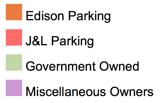
Explore an interactive map of the 300+ acres of parking in Downtown Newark. This map is part of PLANewark’s ongoing fight against the expansion of surface parking in Newark. Click the rectangle icon on upper right hand corner of map to view full screen. Click on individual, color-coded lots to view information on the property owner and acreage.

.

Interactive map of Newark’s blight of parking

.

.

Destruction of the James Street Commons: 1975-2020

This map (accurate as of April 2021) illustrates buildings demolished in one Newark neighborhood, the James Street Commons. When historians first considered this neighborhood for landmark status in 1975, there were 425 historic buildings. Even after earning landmark status in 1978, demolitions and urban decay continued. Rutgers, Edison Parking, St. Michael’s Hospital, and the New Jersey Institute of Technology have demolished dozens of old buildings, mostly to construct surface parking lots as an “interim” land use. It is time that the local and state governments be more proactive in preserving the city’s history.

.