• This website includes dozens of videos, hundreds of essays, and thousands of drawings created over the past twenty years. Search to learn more about the history of buildings, places, prisons, Newark, New York City, and my PhD research on spatial inequality.

  • Or scroll down for the latest publications.

Homeownership and the Racial Wealth Gap

Presented March 5, 2024 at the Newark Public Library

.

.

The world’s largest concentration of wealth is in the New York City metropolitan area, yet the region contains many under-resourced cities, including Newark. What historical factors created this division between low-income Newark and its wealthy neighbors along lines of race, housing, income and social class?
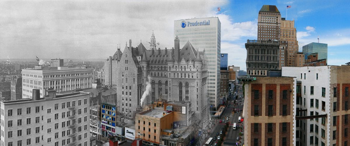
The agents of change are more complex and nuanced than a simple narrative of redlining and white flight following the 1967 uprising. From discriminatory actions by the Federal Housing Administration and highways that carved through the urban fabric, to suburbs that pulled middle-class families away from Newark and factories that relocated outside of the city, contemporary poverty in Newark was more than a century in the making.
Drawing from the archives of the Newark Public Library, this presentation examines the range of challenges Newark faces and how the city overcomes. This is a Newark History Society program, co-sponsored by NJPAC and the Newark Public Library. Light refreshments will be served.
The presenter is Myles Zhang, urban historian and doctoral candidate at the University of Michigan in Ann Arbor.
This presentation will evolve into my dissertation entitled:
“An island of poverty in a vast ocean of material prosperity”:
Homeownerhip and the Racial Wealth Gap in Newark

.

.

.

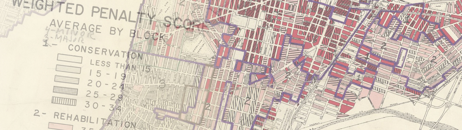
1959 Map of “Blighted” Areas by Newark Central Planning Board

.

View event on NJPAC website

Eastern State Penitentiary Construction Sequence

Time-lapse animation of the prison’s entire design – building by building virtual model – from the 1820s to present.

.

“The founders of a new colony, whatever Utopia of human virtue and happiness, allot a portion of the virgin soil as a cemetery, and another portion as the site of a prison.”
Nathaniel Hawthorne, The Scarlet Letter, 1850

.

.

Based on:
– Historic architectural plans (1837 report in French, pp. 124-38)
– Primary sources (1830 description)
– Reports on the historic preservation of this prison (1994 Historic Structures Report, Volume II)
Music by Philip Glass from the 1982 film Koyaanisqatsi, starting at minute 37:30
Link to text of audio narration

.

Computer Model

Shows prison as it appeared in the period 1836 to 1877 before later construction obstructed the original buildings.

.

The City as Carceral State

Context: The following personal essay accompanied my application for the Gupta Values Scholarship from the University of Michigan. I am sharing it here because it speaks more broadly to my background, education, activism, and research interests.

.

Entrance gate to the Old Essex County Jail

.

One out of every one hundred black men in my neighborhood of Newark, NJ is currently in prison. At least half have a permanent criminal record as formerly incarcerated people. Most charges are for drug use and possession, often marijuana records from when marijuana was illegal. My earliest memories of Newark are of the homeless walking down our street to the nearby food pantry and young men carrying boom boxes on their shoulders (this was before the iPod). I will always remember observing one woman as she passed our house each day. The first time I saw her, she had been recently evicted and dragged two suitcases behind her. With each passing week, the suitcases gradually grew lighter until – after several weeks – all she had left was a grocery bag of belongings, her dignity gradually stripped away. Up our street was the public housing project of Baxter Terrace – three-story red brick barracks where the urban poor lived under constant police surveillance. Most were unemployed and all were on public welfare.
I remember taking the train to school in the suburbs. In the span of only five miles, vacant lots and abandoned buildings in one of the nation’s poorest cities gave way to large homes on tree-lined streets in one of the nation’s wealthiest suburbs. The distance of five miles – or in some cases a single city street – was all that separated the poverty of my city from the wealth of its suburbs. At the city limits of Newark, a system of one-way roads, streets without sidewalks, and aggressive “neighborhood watch” signs separated the city from the suburb. On one block, apartment buildings, treeless streets, and bodegas that accepted food stamps. Just one block over, there were century-old trees and four-bedroom homes selling for up to a million dollars. Here in these suburbs, homeowners commuted to Downtown Newark each day and returned home each night, bringing home with them the wealth they made in the city. So little and yet so much separated these two worlds.
Martin Luther King described America in a 1968 speech he gave in Detroit: “There are literally two Americas.  Every city in our country has this kind of dualism, this schizophrenia, split at so many parts, and so every city ends up being two cities rather than one. There are two Americas. One America is beautiful for situation. [….] But there is another America. In this other America, thousands and thousands of people, men in particular walk the streets in search for jobs that do not exist.” So much and yet so little has changed since 1968. The racial wealth gap is almost the same today as it was in 1970. In Newark, median black family income is less than $30,000. In Newark suburbs, median family incomes are over $100,000.

Read More

.

“Where Evil Dwells” at Newark’s Old Essex County Jail

As originally published in The Newarker, December 2020


Photo by Madeline Berry

“The founders of a new colony, whatever Utopia of human virtue and happiness they might originally project, have invariably recognized it among their earliest practical necessities to allot a portion of the virgin soil as a cemetery, and another portion as the site of a prison.”
– Nathaniel Hawthorne, The Scarlet Letter, 1850
When citizens convened in 1836 to incorporate Newark as a city, one of their first orders of business was to discuss the construction of a new jail. Four years earlier, they had set aside land for the new cemetery. The previous year, the old county courthouse and jail had burned down in one of the fires that periodically swept through early American towns of wood-frame homes. All traces of this old courthouse are now gone, except for the building’s basement dungeon where convicts were kept awaiting trial. Remnants of this dungeon are still visible in the dark crawlspace beneath the sanctuary of Grace Church on Broad Street.
This quiet village was already approaching 170 years old. Newark’s population numbered only 10,542 free white Americans, 6,000 Irish, 1,000 English and Scotch, 300 Germans and 358 free colored people in 1835. Within the span of a few months, in 1836, the town’s first two railroads linked Newark to points west and south; oil streetlights illuminated the town center; the first school system for poor children opened; and another fire swept through downtown. In the next few decades, the population would grow almost ten percent every year. Newark was fast becoming a city.
However, Newark remained in many ways a farming hamlet with Puritan roots. Since 1666, the annual town meetings had been held in the courthouse, the “Court Room at Moses Roff’s Taven,” or inside one of the lecture rooms of Old First Presbyterian Church near the corner of Broad and Market Streets. The sexton of Old First was, in fact, paid three dollars per year by the Town Committee “for cleaning the Lecture room of said Church.” The names of attending officials read like a list of street names from a modern Newark address book: Treat, Baldwin, Bruen, Pennington, Doremus, Halsey, Harrison, Frelinghuysen, etc. The lands they farmed and passed down through generations span much of present-day Essex County.
In the expanding town, it was no longer possible “to Farm let” the city’s debtors and poor to the lowest bidder, who in the years before the American Revolution paid £159 for the privilege. Nor was it possible to use fines as punishment for the most common public nuisances, which included escaped hogs and cattle roaming Newark’s dirt streets due to poorly maintained fences. The town records had noted few serious crimes like rape or murder in more than a century. Nonetheless, with waves of “rowdy” German and Irish immigrants soon to come, Newark needed a jail.

Read More

.

Newark Changing: Mapping neighborhood demolition, 1950s to today


Click to launch interactive mapping experience.

.

Newark Changing is a first-of-its-kind visual encyclopedia of 2,400 photo comparisons of almost every street corner​​​, home, and building ​​demolished by urban renewal and the social forces behind urban decay.​ Through an interactive and text-searchable historic map, any visitor can travel in time to explore their street and their building as it appeared in the period 1959-68 vs. today. Thousands of old street photos are brought to life with contemporary 360-degree panoramic photos of the same street scenes today, taken from identical camera angles to the old photos. This is the most extensive collection of photo comparisons past and present ever assembled for any American city.
Newark Changing reveals the scale and devastation of urban renewal, not from the aerial perspective of the city planner’s map but from the human perspective of the street corner and neighborhood. Tens of thousands of individual streets, homes, apartments, churches, and Jewish, Black, and Italian-owned businesses in Newark were “redlined” in the 1930s and deprived of investment. Most of these neighborhoods today have been bulldozed for interstate highways, universities, hospitals, and corporate investments in real estate. Billions in taxpayer money (adjusted for today’s value with inflation) was spent in the period 1945 to 1967 to demolish at least 10,000 buildings, displacing 50,000 people, 65-77% of whom were Black. At the same time, the migration of people and jobs away from urban centers deprived cities like Newark of the industrial employment base they once had. Decades after the 1967 rebellion, Newark still struggles to confront and overcome decades of harm inflicted on the city by de-industrialization and population loss to the suburbs.
Street scenes can be browsed by interactive map, by neighborhood, by subject, by street, or by the public institution responsible for demolition. Visitors can thus travel in time to explore today’s empty fields, parking lots, and desolate streetscapes for the vibrant neighborhoods they were before the automobile age.

Launch interactive mapping experience >

A park without trees creates a city without history.

Harriet Tubman Square has the largest and most impressive collection of old-growth trees in Downtown Newark. The oldest trees are over 100 feet high, four-feet diameter at the trunk, and up to 150 years old. The City of Newark’s current proposal is to cut every single tree in our park. The only historical precedent for this is the 1960s project that killed every tree in Military Park to build the parking garage now buried beneath. Based on details and architectural plans revealed through an Open Public Records Act request, this animation shows what is planned for our park:

.

Read the plans for the park.

Read our analysis of these plans.

.

.

We cheer for the historic Harriet Tubman Park for a new, prosperous, and most of all just Newark.
However, nobody should even imagine cutting down these 66 century-old trees, oaks, elms, sycamores, all of which represent our history and particularly African-American experience. In America, trees symbolize both freedom and brutal oppression, should any sensible person forget. Unlike any historic treasures – architectural remnants, shriveled old maps, aged documents, or battled artifacts – these trees are among our most valuable historic icons, standing tall for our children.
Tubman embodied the notion of reclaiming the symbolism of trees and woods as tools of freedom in the black tradition. In the antebellum America, abolitionists always voiced lyrics about glorious trees that bore the fruit of freedom. Dr. Martin Luther King famously said, “Even if I knew tomorrow the world would go to pieces, I would still plan my apple tree.” Tubman was famous for knowing the terrain of trees, woods, and swamps along her journey to freedom. In Tubman’s biography by Sarah Bradford, the black Moses said, “When I found I had crossed that line, I looked at my hands to see if I was the same person. There was such a glory over everything; the sun came like gold though the trees, and over the fields, and I felt like I was in Heaven.”
On the other hand, Billie Holiday sang about fruits produced by these trees: “Southern trees bear strange fruit/Blood on the leaves and blood at the root/Black bodies swing in the southern breeze/Strange fruit hanging from the poplar trees/ …Here is a strange and bitter crop.” The blood of black men, women, and children who refused to remain silent, and who deserve justice, life, liberty, and love, over the hate that surround them.
Last year, Rutgers Newark restored the history and voices of Frederick Douglass in the Historic James Street Commons. Let us not forget, Douglas also said, “If Americans wished to partake of the tree of knowledge, they would find its fruit bitter as well as sweet.” It is unimaginable that Tubman will allow these venerable trees of knowledge to be annihilated.

A Different Kind of Radiant City: Bucharest

Comparing Le Corbusier’s plans for Paris with Ceaușescu’s plans for Bucharest

.

.

Abstract: Comparing Le Corbusier’s unrealized plans for Paris and dictator Nicolae Ceaușescu’s completed plans for the Romanian capital Bucharest reveals similarities in their urban forms. Analysis of three features in both cities – their nineteenth-century urban forms, the integration of twentieth-century plans into the existing urban forms, and the political symbolism of each plan – reveals the two places as reflections of each other. The comparison matters because it establishes an unconscious aesthetic link between the progressive (almost utopian) urban designs of an architect like Le Corbusier and the repressive (almost dystopian) urban designs of a dictator like Ceaușescu.

.

Utopia and totalitarianism are both engaged in a mirroring game, tirelessly sending the same image back and forth as if utopia were nothing more than the premonition of totalitarianism and totalitarianism the tragic execution of the utopian dream. Only the distance that separates a dream from its realization seems to stand between the two.

– Frédéric Rouvillois
Utopia: The Search for the Ideal Society in the Western World [1]

.

Read More

.

Branch Brook Park Interactive History Map

As featured by the Branch Brook Park Alliance as the official park map

.

Navigate this interactive history map of Newark’s Branch Brook Park. Click on map features to learn about park amenities, recreational spaces, and historic features. Map annotations are paired with explanatory texts and comparative photos of past and present. Beneath each annotation is the Google Maps link that will display directions to that point in the park from wherever you are standing.
All historic images are from the archives of the Essex County Parks Department and Newark Public Library. Browse their digital collections or contact the agency to visit their archives. All descriptions are sourced from the Cultural Landscape Report that documented the park’s history and renovation.
Map created by Myles Zhang
Map texts by Linda Morgan, Curtis Kline, Myles Zhang, Maeher Khosla, and Jack Barron
Contemporary photos by Curtis Kline with Mouli Luo

.

Read More

.